


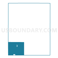
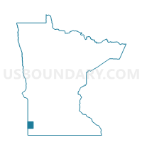
Eden Twp. Voting District, Pipestone County, Minnesota
About
Outline

Summary
| Unique Area Identifier | 603650 |
| Name | Eden Twp. Voting District |
| County | Pipestone County |
| State | Minnesota |
| Area (square miles) | 43.03 |
| Land Area (square miles) | 42.79 |
| Water Area (square miles) | 0.23 |
| % of Land Area | 99.45 |
| % of Water Area | 0.55 |
| Latitude of the Internal Point | 43.89568490 |
| Longtitude of the Internal Point | -96.37441230 |
Maps

Graphs
Select a template below for downloading or customizing gragh for Eden Twp. Voting District, Pipestone County, Minnesota


Neighbors
Neighoring Voting District (by Name) Neighboring Voting District on the Map
- Elmer Twp. Voting District, Pipestone County, MN
- Gray Twp. Voting District, Pipestone County, MN
- Ihlen Voting District, Pipestone County, MN
- Jasper Voting District, Rock County, MN
- Jasper Voting District, Pipestone County, MN
- Rose Dell Twp. Voting District, Rock County, MN
- Sweet Twp. Voting District, Pipestone County, MN
- VTD VP10, Minnehaha County, SD
- VTD-precinct 3, Moody County, SD
Top 10 Neighboring County Subdivision (by Population) Neighboring County Subdivision on the Map
- Jasper city, Pipestone County, MN (573)
- Sweet township, Pipestone County, MN (324)
- Eden township, Pipestone County, MN (278)
- Elmer township, Pipestone County, MN (231)
- Gray township, Pipestone County, MN (225)
- Rose Dell township, Rock County, MN (216)
- Highland township, Minnehaha County, SD (191)
- Lone Rock township, Moody County, SD (99)
- Alliance township, Moody County, SD (95)
- Ihlen city, Pipestone County, MN (63)
Top 10 Neighboring Place (by Population) Neighboring Place on the Map
Top 10 Neighboring Unified School District (by Population) Neighboring Unified School District on the Map
- Pipestone Area School District, MN (7,718)
- Dell Rapids School District 49-3, SD (5,508)
- Flandreau School District 50-3, SD (3,907)
Top 10 Neighboring State Legislative District Lower Chamber (by Population) Neighboring State Legislative District Lower Chamber on the Map
- State House District 22A, MN (34,781)
- State House District 25, SD (22,548)
- State House District 8, SD (20,647)
Top 10 Neighboring State Legislative District Upper Chamber (by Population) Neighboring State Legislative District Upper Chamber on the Map
- State Senate District 22, MN (71,339)
- State Senate District 25, SD (22,548)
- State Senate District 8, SD (20,647)
Top 10 Neighboring 111th Congressional District (by Population) Neighboring 111th Congressional District on the Map
Top 10 Neighboring Census Tract (by Population) Neighboring Census Tract on the Map
- Census Tract 101.01, Minnehaha County, SD (4,601)
- Census Tract 9596, Moody County, SD (3,313)
- Census Tract 5701, Rock County, MN (2,490)
- Census Tract 4604, Pipestone County, MN (1,714)